Google Maps 将会在今天推出更新 v6.10,最主要改动是加入全球 500 多个城市的公共交通服务时间表,包括有钮约, 伦敦, 东京和悉尼,当然也有香港和台湾等地。
Today, Google Maps has public transportation schedules for more than one million transit stops worldwide, in nearly 500 cities including New York, London, Tokyo and Sydney.
根据 Google 的资料,香港的交通资料包括几间巴士公司,渡轮公司,港铁,电车,山顶缆车和昂坪 360等。而台湾则包括有高铁, 铁路, 台北和高雄捷运, 和其他的公共汽车和客运等。
http://www.google.com/intl/en/landing/transit/text.html#as
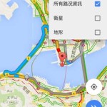
而操作界面方面,新的 Google Maps 可选择显示单一的公共交通工具,而车站页面亦会列出开车时间, 路线和邻近车站距离等。


另外,新版本还有其他的改动
– Now, whenever you search for a city or postal code, the borders of that region are highlighted.
– Under My Places you’ll notice we’ve added new tabs, which will help you access all your information from a single place; from your saved maps for use offline to your starred places and Custom Maps created on your desktop.
– If you enable Location History, you’ll be able to browse the places you’ve been on a daily basis with an updated Location History dashboard.
新的 Google Maps 今天会在 Google Play Store 发布,但撰写此文时,还未推出。各位可稍后再留意是否有更新。
资料来源:Google Lat Long Blog